FIRST AMENDMENT TO LEASE AGREEMENT
Exhibit 10.40
FIRST AMENDMENT TO LEASE AGREEMENT
THIS FIRST AMENDMENT TO LEASE AGREEMENT shall supplement and form a part of a lease agreement
(“Lease”) dated July 23, 1999, by and between CB PARKWAY BUSINESS CENTER V, LTD., a Texas
limited partnership (“Landlord”), and REALPAGE, INC., a Texas corporation
(“Tenant”), for Suite 1000, 0000 Xxxxxxxxxxxxx Xxxxxxx, Xxxxxxxxxx, Xxxxx, as more
particularly described upon Exhibit A to the Lease. The Lease is incorporated herein by reference.
Where any terms or conditions contained herein conflict with any terms or conditions contained in
the Lease, the terms and conditions contained herein shall control. Otherwise, the Lease is
ratified and affirmed and all terms and conditions therein shall remain in full force and effect.
Terms herein not otherwise defined shall have the same meanings ascribed to such terms in the
Lease.
IN CONSIDERATION OF the mutual covenants and conditions stated in the Lease and herein, and
other good and valuable consideration, the receipt and sufficiency of which are hereby
acknowledged, Landlord and Tenant agree as follows:
| 1. | The second paragraph of Exhibit F Parking shall be modified to read that “In addition to the parking spaces in the Parking Area, Landlord shall provide on or before April 1, 2000 and Tenant shall be permitted the exclusive use of 111 parking spaces (the “Offsite Spaces”) in the areas depicted on Exhibit F-1 attached hereto (the “Offsite Parking Area”) throughout the Term or any renewal or extension thereof. Landlord (or one of its affiliates shall, at its sole cost and expense (and not as part of Basic Cost), grade, pave, landscape, install lighting and stripe the Offsite Parking Area needed to provide the Offsite Spaces. In accordance with the terms of the Parking Easement Grant and Maintenance Agreement, Landlord’s Affiliate (or successor in interest) shall maintain the Offsite Spaces in good order, condition and repair, and shall be responsible for sweeping, striping and lighting the Offsite Spaces, with the cost of such services to be charged to Tenant.” | ||
| 2. | Exhibit F-1 Reciprocal Easement Grant and Maintenance Agreement to the Lease shall be replaced with the attached Exhibit F-1 Parking Easement Grant and Maintenance Agreement. | ||
| 3. | As amended herein, the Lease is affirmed, ratified and remains in full force and effect. | ||
| DATED: November 29, 1999 |
| LANDLORD: | TENANT: | |||||||||
| CB PARKWAY BUSINESS CENTER V,
LTD., a Texas limited partnership |
REALPAGE, INC., a Texas corporation | |||||||||
| By: 15BCO, Inc., a Texas corporation, its General Partner | ||||||||||
By:
|
/s/ Xxxxxxx Xxxxxx
|
By: | /s/ Xxxxxxx X. Xxxx
|
|||||||
| Title: Vice President | Title: Chairman of the Board | |||||||||
EXHIBIT F-1
After recording, return to:
Xxxx X. Xxxxxxxx
Xxxxxxxxxxx Company
0000 Xxxx Xxxxxx, Xxxxx 0000 Xxxx
Xxxxxx, Xxxxx 00000
Xxxx X. Xxxxxxxx
Xxxxxxxxxxx Company
0000 Xxxx Xxxxxx, Xxxxx 0000 Xxxx
Xxxxxx, Xxxxx 00000
PARKING EASEMENT GRANT AND MAINTENANCE AGREEMENT
THIS AGREEMENT is made this 18thday of November, 1999, by and between the
present owners of those certain tracts of real property situated in Xxxxxx County, Texas described
on Exhibit A and Exhibit B.
RECITALS:
(1) CB PARKWAY BUSINESS CENTER V, LTD., a Texas limited partnership (“CB V”) is the owner of a
certain tract of real property situated in Xxxxxx County, Texas, described on Exhibit A
attached hereto (“Tract I”), and any improvements now or hereafter located thereon (the “Tract I
Improvements”).
(2) CB MIDWAY/PARKWAY INVESTORS, LTD., a Texas limited partnership (“CB MPI”) is the owner of
a certain tract of real property situated in Xxxxxx County, Texas, described on Exhibit B
attached hereto (“Tract II”) and any improvements now or hereafter located thereon (the “Tract II
Improvements”).
(3) As used herein, the term “Tract I Owner” shall mean CB V, acting in its capacity as the
owner of Tract I, the term “Tract II Owner” shall mean CB MPI, acting in its capacity as the owner
of Tract II. The Tract I Owner and Tract II Owner are referred to herein individually as an
“Owner” and collectively as the “Owners”. Tract I and Tract II are referred to herein individually
as “Tract” and collectively as “Tracts”.
(4) The purpose of this Agreement is to (i) provide for an access and parking easement on
Tract II for the benefit of the Tract I owner and (ii) to set forth certain agreements between the
Tract I Owner and the Tract II Owner with regard to the costs and expenses of constructing and
maintaining such parking areas.
AGREEMENT:
In consideration of the premises and the mutual agreements herein contained, the Tract I Owner
and the Tract II Owner hereby covenant and agree as follows and hereby GRANT, BARGAIN, SELL, CONVEY
and, where appropriate, RESERVE the easement hereinafter set forth.
ARTICLE I
Tract II Parking Easements
1.1 Grant of Tract II Parking Easements. The Tract II Owner hereby grants and conveys
to the Tract I Owner, for the benefit of and appurtenant to Tract I, exclusive easements in, to,
over and across the
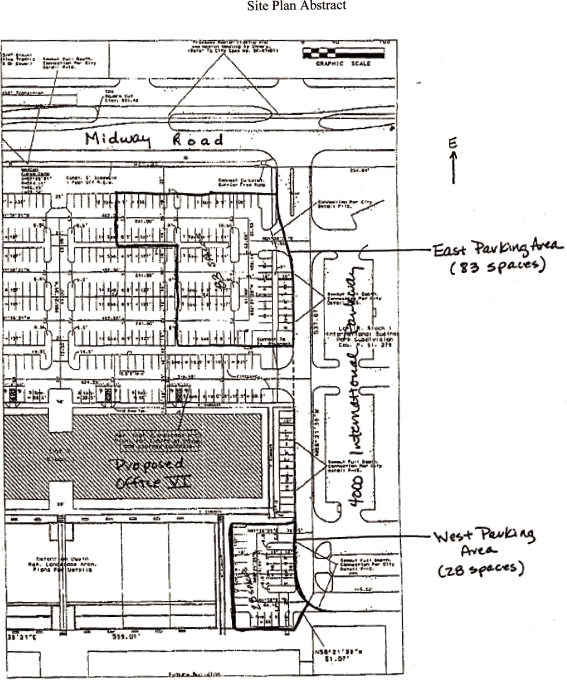
areas on Tract II described in Exhibits C and D and depicted on the abstract from the
site plan of Tract II prepared by RLK Engineering dated August 20, 1999, (the “Site Plan”) as the
East Parking Area and West Parking Area respectively, a copy of which is attached hereto as
Exhibit E, for the purpose of providing 108 parking spaces (the “Parking Easements”) for
use by vehicles no longer than full-size passenger automobiles or 1/2-ton pickup trucks.
1.2 Term of Parking Easements. The Tract II parking easements shall survive for the
lease term, including renewals and extensions, of the Lease Agreement dated July 23, 1999, by and
between CB Parkway Business Center V, Ltd., a Texas limited partnership, and RealPage, Inc., a
Texas corporation.
1.3 Construction of Parking Easement Areas. The Tract II Owner agrees to design and
construct the initial parking areas and drives included within the Parking Easement areas.
1.4 Maintenance of Parking Easements. The Tract II Owner agrees for himself and for
future owners of Tract II, to at all times maintain in good repair and condition all portions of
the Tract II Parking Easements and to keep them, at all times, free and clear from all debris and
other obstructions which would or might unreasonably interfere with its use for vehicular parking.
All reasonable costs incurred by the Tract II Owner in maintaining, repairing and replacing the
Tract II Parking Easements shall be paid by the Tract I Owner until this easement terminates.
ARTICLE II
Miscellaneous
2.1 Binding Effect. Except as expressly set forth herein, the easement and covenants
set forth in this Agreement shall run with the land, and shall be binding upon any and all parties
hereafter acquiring an interest in Tract I or Tract II, and shall inure to the benefit of and be
binding upon the respective successors and assigns of the parties benefitted and burdened hereby
and shall remain in effect as hereinabove set forth.
2.2 Exhibits. The exhibits referred to in this Agreement and attached hereto are
incorporated herein in full by this reference.
2.3 Waiver. No failure of any party to exercise any power given to such party
hereunder or to insist upon such strict compliance by any other party to its obligations hereunder
and no custom or practice of the parties in variance with the terms hereof shall constitute a
waiver of any party’s right to demand exact compliance with the terms hereof.
2.4 No Dedication. Nothing contained in this Agreement is intended to, nor shall it
be constructed as, dedicating any easement or rights to the public.
2.5 Enforcement of Obligations. In the event that any party obligated hereunder (the
“Obligated Party”) fails to undertake and perform punctually and properly any of his or its duties
or obligations set forth in this Agreement, then any other owner of Tract I or Tract II (the “Other
Party”) shall give the Obligated Party written notice of such failure and shall give the Obligated
Party thirty (30) days after such notice to undertake and perform properly such duty or obligation,
unless such obligation cannot be reasonably completed within such thirty (30) day period, in which
event the Obligated Party shall commence to complete such obligation within such thirty (30) day
period and diligently prosecute to complete same as soon as
reasonably practicable, but in no event more than ninety (90) days after said notice. If the
Obligated Party fails to so undertake and perform properly such duty or obligation within such
thirty (30) day period, or in the event of an obligation which cannot reasonably be completed
within such thirty (30) day period, fails to commence to complete such obligation within such
thirty (30) day period and thereafter diligently prosecute to complete same as soon as reasonably
practicable, but in no event more than ninety (90) days after said notice, then the Other Party
may, but shall not be required to, undertake and perform such duty or obligation for and on behalf
of the Obligated Party, all costs and expenses of which shall be paid to the Other Party by the
Obligated Party. If the Other Party retains an attorney to collect such amount, then the Obligated
Party shall also pay reasonable attorney’s fees and costs of collection. Notwithstanding anything
to the contrary herein, in the event of an emergency whereby immediate action is required to
prevent damage or injury to persons or property, the Other Party may undertake any reasonably
necessary obligations of the Obligated Party without prior notice or demand, and shall be entitled
to reimbursement of all reasonably incurred expenses in connection therewith as provided herein.
Each party hereto hereby grants to the other party hereto and/or reserves, as appropriate, an
easement on, over and across the Tract owned by the Obligated Party for any reasonable use in
connection with the performance by the Other Party of the obligations of the Obligated Party
pursuant to this Section 2.5. In addition to the right of the Other Party to perform the
obligations of the Obligated Party pursuant to this Section 2.5, the obligations of any party to
this Agreement may be enforced by any other measure available at law or in equity, including
without limitation the right to obtain injunctive relief.
2.6 Payments. Where any payments hereunder are owed by an Owner (the “Payor Owner”)
to the other Owner (the “Payee Owner”), such payment shall be due and payable within thirty (30)
days after the Payor Owner receives written notice from the Payee Owner of the amount thereof
together with copies of all applicable receipts and other reasonable verification of such amount,
if applicable. If not paid when due, such amounts shall bear interest from the due date at the
rate of ten percent (10%) per annum or the highest rate then allowed under applicable law,
whichever is lower, until paid. In addition, any proper amounts owed hereunder if not paid when
due shall be secured by a lien on the Payor Owner’s Tract, which lien shall be effective upon the
recording of a legally sufficient notice thereof in the real property records for Dallas County,
Texas. Such lien shall be subordinate to any mortgage or deed of trust now or hereafter affecting
such Tract, and any purchaser at any foreclosure or trustee’s sale (as well as any grantee by deed
in lieu of foreclosure or trustee’s sale) under any such mortgage or deed of trust shall take title
subject only to liens thereafter accruing pursuant to this Section.
2.7 Amendment. This Agreement, and any rights or interests herein granted, bargained,
sold, conveyed, reserved or otherwise provided, may be amended, modified or terminated only by a
written and duly recorded agreement signed by all Owners and mortgagees having a valid lien on any
portion of the Tracts.
2.8 Responsibility. Notwithstanding anything to the contrary herein, each Owner shall
be liable and responsible for the obligations, covenants, agreements and responsibilities created
by this Agreement and for any judgement rendered hereon only to the extent of its respective
interest in the land and improvements on its respective Tract.
2.9 Estoppel Certificates. Each Owner agrees that upon written request of the other
Owner, it will issue, within thirty (30) days after receipt of such request, an estoppel
certificate stating to the best of the issuer’s knowledge the status of any matter relating to this
Agreement or the terms hereof as shall be reasonably requested by the other Owner.
2.10 Notices. Any notice required or permitted hereunder must be in writing and may
be delivered to the respective addresses and numbers of the parties listed below (which addresses
and numbers may be changed upon two (2) days notice), either in person, by certified U.S. Mail, by
reputable overnight delivery service, or by facsimile copy via telecopy. Any such notice shall be
deemed effective upon the earlier of actual delivery, upon the third day following deposit in the
U.S. Mail, certified mail with return receipt requested, postage prepaid and properly addressed, or
upon successful telecopy transmission as evidenced by acknowledgment of successful transmission by
the sending machine
TRACT I OWNER:
|
TRACT II OWNER: | |
CB Parkway Business Center V, Ltd.
|
CB Midway/Parkway Investors, Ltd. | |
c/o Billingsley Company
|
c/o Billingsley Company | |
0000 Xxxx Xxxxxx
|
2200 Xxxx Avenue | |
Suite 0000 Xxxx
|
Xxxxx 0000 Xxxx | |
Xxxxxx, Xxxxx 00000
|
Xxxxxx, Xxxxx 00000 | |
Attn: Xxxx X. Xxxxxxxx
|
Attn: Xxxx X. Xxxxxxxx | |
Telephone: (000) 000-0000
|
Telephone: (000)-0000000 | |
Telecopy: (000) 000-0000
|
Telecopy: (000) 000-0000 | |
with copy to:
|
with copy to: | |
Xxxxx & Xxxxx, L.L.P.
|
Xxxxx & Xxxxx, L.L.P. | |
0000 Xxxx Xxxxxx
|
0000 Xxxx Xxxxxx | |
Xxxxxx, Xxxxx 00000-0000
|
Xxxxxx, Xxxxx 00000-0000 | |
Attn: Xxxx Xxxxxxx, Xx.
|
Attn: Xxxx Xxxxxxx, Xx. | |
Telephone: (000) 000-0000
|
Telephone: (000) 000-0000 | |
Telecopy: (000) 000-0000
|
Telecopy: (000) 000-0000 |
2.11 Waiver of Claims: No Subrogation. Notwithstanding anything herein to the
contrary, each Owner hereby waives any rights of recovery against the other, its owners, partners,
managers, agents, employees, contractors, tenants, occupants, guests or invitees for any damage or
loss that may occur on the Tracts or on or to any improvements thereon or other property therein,
by reason of fire, the elements or any other cause which could be insured under a standard all
risks insurance policy, regardless of cause or origin, including without limitation any negligent
acts or omissions of the other Owner, its owners, partners, managers, agents, employees,
contractors, tenants, occupants, guests or invitees, and no insurer shall have any rights of
subrogation with respect to the foregoing.
2.12 Counterparts. This Agreement may be signed by the parties in counterparts, which
when taken together, shall constitute a valid, binding and effective agreement.
IN WITNESS WHEREOF, the parties have executed this Agreement as of the day and year first
above written.
| “TRACT I OWNER” CB PARKWAY BUSINESS CENTER V, LTD., a Texas limited partnership |
||||
| By: | 15BCO, INC., General Partner | |||
| By: | /s/ Xxxxxxx X. Xxxxxx | |||
| Name: | Xxxxxxx X. Xxxxxx | |||
| Title: | Vice President | |||
| “TRACT II OWNER” CB MIDWAY/PARKWAY INVESTORS, LTD., a Texas limited partnership |
||||
| By: | 2BCO, INC., General Partner | |||
| By: | /s/ Xxxxxxx X. Xxxxxx | |||
| Name: | Xxxxxxx X. Xxxxxx | |||
| Title: | Vice President | |||
STATE OF TEXAS
|
§ | |
| § | ||
COUNTY OF DALLAS
|
§ |
This instrument was acknowledged before me on 18th day of November, 1999,
by Xxxxxxx X. Xxxxxx, in her capacity as Vice President of 15BCO, INC., a Texas corporation, in its
capacity as sole general partner of CB PARKWAY BUSINESS CENTER V, LTD., a Texas limited
partnership, on behalf of said corporation and partnership.
| Notary Public, State of Texas |
||||
| /s/ Xxxxxxxxxxx X. Xxxxxxxx | ||||
| Xxxxxxxxxxx X. Xxxxxxxx | ||||
| Printed Name | ||||
| My Commission Expires: 7-28-03 |
||||
STATE OF TEXAS
|
§ | |
| § | ||
COUNTY OF DALLAS
|
§ |
This instrument was acknowledged before me on 18th day of November, 1999,
by Xxxxxxx X. Xxxxxx, in her capacity as Vice President of 2BCO, INC., a Texas corporation, in its
capacity as sole general partner of CB MIDWAY/PARKWAY INVESTORS, LTD., a Texas limited partnership,
on behalf of said corporation and partnership.
| Notary Public, State of Texas |
||||
| /s/ Xxxxxxxxxxx X. Xxxxxxxx | ||||
| Xxxxxxxxxxx X. Xxxxxxxx | ||||
| Printed Name | ||||
| My Commission Expires: 7-28-03 |
||||
EXHIBITS:
Exhibit A — Legal Description of Tract I
Exhibit B — Legal Description of Tract II
Exhibit C — Legal Description of Xxxxx XX Xxxxxxx Xxxxxxxx (Xxxx Xxxxxxx Xxxx)
Exhibit D — Legal Description of Xxxxx XX Xxxxxxx Xxxxxxxx (Xxxx Xxxxxxx Xxxx)
Exhibit E — Site Plan Abstract
Exhibit A
Legal Description — Tract I
0000 Xxxxxxxxxxxxx Xxxxxxx
Xxxxxxxxxx, Xxxxxx Xxxxxx, Xxxxx
0000 Xxxxxxxxxxxxx Xxxxxxx
Xxxxxxxxxx, Xxxxxx Xxxxxx, Xxxxx
Being a 9.672 acre tract of land situated in the X. Xxxxxxx Survey, Abstract No. 1455 in the City
of Carrollton, Xxxxxx County, Texas, said 9.672 acre tract being all of Xxx 0X xx Xxxxx 0 xx
Xxxxxxxxxxxxx Xxxxxxxx Xxxx Subdivision to the City of Carrollton, Texas as recorded in Cabinet P,
Slide 279 of the Plat Records of Xxxxxx County, Texas, said 9.672 acre tract being comprised of two
tracts (0.006 acres and 0.359 acres) out of the X. Xxxxxxx Survey, Abstract No. 1455 conveyed to CB
PARKWAY BUSINESS CENTER V, LTD. by deed recorded in Xxxxxx County Clerk’s File No. 98-R0092891 and
being 9.307 acres (all of Xxx 0 xx Xxxxx 0 xx Xxxxxxxxxxxxx Xxxxxxxx Xxxx Subdivision to the City
of Carrollton, Texas as recorded in Cabinet 0, Slide 352 of the Plat Records of Xxxxxx County,
Texas) out of the 9.554 acre tract of land conveyed to CB PARKWAY BUSINESS CENTER V, LTD. by deed
recorded in Volume 4142, Page 821 of the Real Property Records of Xxxxxx County, Texas, and being
more particularly described as follows:
BEGINNING at a 1/2-inch iron rod with cap set at the northeast corner of said Xxx 0X xx Xxxxx 0 xx
xxx Xxxxxxxxxxxxx Xxxxxxxx Xxxx Subdivision, said point being on the west right of way line of
Midway Road (110 foot wide right of way at this point);
THENCE South 1 degree 38 minutes 21 seconds West, along the west right of way line of Midway Road,
a distance of 254.04 feet to a 1/2-inch iron rod with yellow plastic cap stamped “HALFF ASSOC., INC.”
(hereinafter referred to as “with cap”) set at an angle point in said Midway Road right of way;
THENCE South 5 degrees 27 minutes 09 seconds West continuing along said west right of way line a
distance of 150.35 feet to a 1/2-inch iron rod with cap set for corner;
THENCE South 1 degree 38 minutes 21 seconds West continuing along said west right of way line a
distance of 135.81 feet to a 1/2-inch iron rod with cap set at the point of curvature of a circular
curve to the right having a radius of 80.00 feet and whose long chord bears South 49 degrees 05
minutes 22 seconds West a distance of 117.87 feet;
THENCE in a southwesterly direction along the west right of way of Midway Road and the north right
of way of International Parkway and along said curve to the right through a central angle of 94
degrees 54 minutes 02 seconds, an arc distance of 132.51 feet to a 1/2-inch iron rod with cap found
at the point of compound curvature of a circular curve to the right having a radius of 1215.00 feet
and whose long chord bears North 79 degrees 14 minutes 35 seconds West a distance of 178.72 feet;
THENCE westerly along the north right of way line of International Parkway (a 110 foot wide right
of way at this point) and along said curve through a central angle of 8 degrees 25 minutes 49
seconds, an arc distance of 178.88 feet to a set “X” cut in concrete for corner;
THENCE North 72 degrees 57 minutes 46 seconds West, continuing along the north right of way line of
International Parkway (through a transition in right of way width to 100 feet wide), a distance of
162.38 feet to a set “X” cut in concrete at the beginning of a non-tangent circular curve to the
right having a radius of
Exhibit A
1220.00 feet and whose long chord bears North 65 degrees 07 minutes 30 seconds West a distance of
96.06 feet;
THENCE northwesterly, continuing along the north right of way line of International Parkway (with a
right of way width of 100 feet) and along said curve through a central angle of 4 degrees 30
minutes 45 seconds, an arc distance of 96.08 feet to a found “X” cut in concrete for the point of
tangency;
THENCE North 62 degrees 52 minutes 08 seconds West, continuing along the north right of way line of
International Parkway, a distance of 246.21 feet to a set “X” cut in concrete for the point of
curvature of a circular curve to the right having a radius of 1743.46 feet and whose long chord
bears North 58 degrees 35 minutes 54 seconds West a distance of 259.66 feet;
THENCE northwesterly, continuing along the north right of way line of International Parkway, and
along said curve through a central angle of 8 degrees 32 minutes 28 seconds, an arc distance of
259.90 feet to a 1/2-inch iron rod with cap set for the southwest corner of said Lot 1R of Block 1;
THENCE along the most westerly west line of said Lot 1R of Block 1 the following courses and
distances:
North 35 degrees 40 minutes 20 seconds East, departing said north right of way line of
International Parkway, a distance of 99.24 feet to a 1/2-inch iron rod with cap found at an angle
point in the west line of said Lot 1R of Block 1;
North 01 degrees 38 minutes 21 seconds East a distance of 5.13 feet to a 1/2-inch iron rod with
cap set for a corner;
North 88 degrees 21 minutes 39 seconds West a distance of 12.00 feet to a 1/2-inch iron rod with
cap found for a corner;
North 01 degrees 38 minutes 21 seconds East a distance of 22.00 feet to a 1/2-inch iron rod with
cap found for a corner;
South 88 degrees 21 minutes 39 seconds East a distance of 12.00 feet to a 1/2-inch iron rod with
cap found for corner;
North 01 degrees 38 minutes 21 seconds East a distance of 19.00 feet to a found “X” cut in
concrete for corner;
South 88 degrees 21 minutes 39 seconds East a distance 32.00 feet to a found “X” cut in
concrete for corner;
North 01 degrees 38 minutes 21 seconds East a distance of 32.00 feet to a 1/2-inch iron rod with
cap set at the most westerly northwest corner of said Lot 1R of Block 1;
THENCE South 88 degrees 21 minutes 39 seconds East along the most westerly north line of said Lot
1R of Block 1, a distance of 341.15 feet to set “X” cut in concrete for corner;
Exhibit A
THENCE North 01 degrees 38 minutes 21 seconds East along the most northerly west line of said Lot
1R of Block 1 a distance of 115.02 feet to a found “X” cut in concrete at the most northerly
northwest corner of said Lot 1R of Block 1;
THENCE South 88 degrees 21 minutes 39 seconds East along the most easterly north line of said Lot
1R of Block 1 a distance of 537.07 feet to the POINT OF BEGINNING and containing 421,299 square
feet or 9.672 acres of land more or less.
Exhibit B
Legal Description — Tract II Owner
(30.172 acre tract)
(30.172 acre tract)
BEING a 30.172 acre tract of land situated in the X. Xxxxxxx Survey, Abstract No. 1455 and the X.
Xxxxxx Survey, Abstract No. 882 in the City of Carrollton, Xxxxxx County, Texas, said 30.172 acre
tract being the remainder of that 40.091 acre tract of land conveyed to CB MIDWAY / PARKWAY
INVESTORS, LTD. by the deed recorded in Xxxxxx County Clerk’s file number 94-R0025237 of the Real
Property Records of Xxxxxx County, Texas, said 30.172 acre remainder tract being more particularly
described as follows:
BEGINNING at a point on the existing west right-of-way line of Midway Road (50.00 feet west of its’
center line at this point), said point being South 88 degrees 21 minutes 39 seconds East a distance
of 10.00 feet from a set 1/2-inch iron rod with cap stamped “HALFF ASSOC., INC.” (hereinafter
referred to as “with cap”) at the most easterly northeast corner of Xxx 0X, Xxxxx 0, Xxxxxxxxxxxxx
Xxxxxxxx Xxxx Subdivision as recorded in Cabinet P, Slide 279 of the Plat Records of Xxxxxx County,
Texas;
THENCE North 88 degrees 21 minutes 39 seconds West, departing said west right of way line of Midway
Road, at 10.00 feet passing said set 1/2-inch iron rod with cap stamped “HALFF ASSOC , INC.” at the
most easterly northeast corner of Xxx 0X, Xxxxx 0, Xxxxxxxxxxxxx Xxxxxxxx Xxxx Subdivision, thence
continuing along the most easterly north line of said Lot 1R of Block 1 in all a total distance of
547.07 feet to an “X” cut found in the concrete at the intersection of the most northerly west line
and the most easterly north line of said Lot 1R of Block 1;
THENCE South 01 degrees 38 minutes 21 seconds West along the most northerly west line of said Lot
1R of Block 1, a distance of 115.02 feet to an “X” cut set in the concrete at the intersection of
the most westerly north line and the most northerly west line of said Lot 1R of Block 1;
THENCE North 88 degrees 21 minutes 39 seconds West along the most westerly north line of said Lot
1R of Block 1, a distance of 341.15 feet to a set 1/2-inch iron rod with cap;
THENCE South 01 degrees 38 minutes 21 seconds West along a west line of said Lot 1R of Block 1 a
distance of 32.00 feet to an “X” cut found in concrete for corner;
THENCE North 88 degrees 21 minutes 39 seconds West along a west line of said Lot 1R of Block I a
distance of 32.00 feet to an “X” cut found in concrete for corner;
THENCE South 01 degrees 38 minutes 21 seconds West along a west line of said Lot 1R of Block 1 a
distance of 19.00 feet to a 1/2-inch iron rod with cap found for corner;
THENCE North 88 degrees 21 minutes 39 seconds West along a west line of said Lot 1R of Block 1 a
distance of 12.00 feet to a 1/2-inch iron rod with cap found for corner;
THENCE South 01 degrees 38 minutes 21 seconds West along a west line of said Lot 1R of Block 1 a
distance of 22.00 feet to a 1/2-inch iron rod with cap found for corner;
THENCE South 88 degrees 21 minutes 39 seconds East along a west line of said Lot 1R of Block 1 a
distance of 12.00 feet to a set 1/2-inch iron rod with cap for corner;
Exhibit B
THENCE South 01 degrees 38 minutes 21 seconds West along a west line of said Lot 1R of Block 1 a
distance of 5.13 feet to a 1/2-inch iron rod with cap found for corner;
THENCE South 35 degrees 40 minutes 20 seconds West along a west line of said Lot 1R of Block 1 a
distance of 99.24 feet to a 1/2-inch iron rod with cap found on a circular curve to the right
having a radius of 1743.46 feet and whose long chord bears North 43 degrees 18 minutes 53 seconds
West a distance of 666.12 feet;
THENCE Northwesterly, along the north right-of-way line of International Parkway, and along said
curve through a central angle of 22 degrees 01 minute 35 seconds, an arc distance of 670.24 feet to
a point for corner;
THENCE North 45 degrees 09 minutes 23 seconds East, departing said north right-of-way line of
International Parkway, a distance of 1301.84 feet to a point for corner, said corner being at the
southwest corner of a tract of land conveyed to Xxxxxxx Financial Group, Ltd. by a deed recorded in
Volume 3116 Page 249 of the Deed Records of Xxxxxx County, Texas;
THENCE South 87 degrees 53 minutes 50 seconds East, along the south line of said Xxxxxxx Financial
Group Ltd. tract, a distance of 550.00 feet to a found 5/8-inch iron rod on the west right-of-way
line of Midway Road (a 100 foot wide right-of-way at this point);
THENCE South 1 degree 38 minutes 21 seconds West, along the west right-of-way line of Midway Road,
a distance of 1135.61 feet to the POINT OF BEGINNING and containing 1,314,214 square feet or 30.172
acres of land more or less.
BASIS OF BEARING: The monumented most easterly north line of Xxx 0X xx Xxxxx 0 xx Xxxxxxxxxxxxx
Xxxxxxxx Xxxx Subdivision as recorded in Cabinet P, Slide 279 of the Plat Records of Xxxxxx County,
Texas, with a record bearing of North 88 degrees 21 minutes 39 seconds West.
Exhibit C
Tract II Parking Easement
(West Parking Area — Legal Description)
28 Parking Spaces
(West Parking Area — Legal Description)
28 Parking Spaces
BEING a tract of land situated in the X. Xxxxxxx Survey, Abstract No. 1455 in the City of
Carrollton, Xxxxxx County, Texas and being part of that tract of land conveyed to CB MIDWAY/PARKWAY
INVESTORS, LTD. by deed recorded in Xxxxxx County Clerk’s file number 94-R0025237 of the Real
Property Records of Xxxxxx County,-Texas, and being more particularly described as follows:
COMMENCING at a point on the existing west right-of-way line of Midway Road (50.00 feet west of
its’ center line at this point), said point being South 88 degrees 21 minutes 39 seconds East a
distance of 10.00 feet from a set 1/2-inch iron rod with cap stamped “HALFF ASSOC., INC.” at the
most easterly northeast corner of Xxx 0X, Xxxxx 0, Xxxxxxxxxxxxx Xxxxxxxx Xxxx Subdivision as
recorded in Cabinet P, Slide 279 of the Plat Records of Xxxxxx County, Texas;
THENCE North 88 degrees 21 minutes 39 seconds West, departing said west right of way line of Midway
Road, at 10.00 feet passing said set 1/2-inch iron rod with cap stamped “HALFF ASSOC., INC.” at the
most easterly northeast corner of Xxx 0X, Xxxxx 0, Xxxxxxxxxxxxx Xxxxxxxx Xxxx Subdivision, thence
continuing along the most easterly north line of said Lot 1R of Block 1 in all a total distance of
547.07 feet to an “X” cut found in the concrete at the intersection of the most northerly west line
and the most easterly north line of said Lot 1R of Block 1;
THENCE North 58 degrees 21 minutes 39 seconds West, departing from the most easterly north line of
said Lot 1R of Block 1, a distance of 13.98 feet to the POINT OF BEGINNING of the herein described
tract of land;
THENCE North 58 degrees 21 minutes 39 seconds West a distance of 37.08 feet to a point for corner;
THENCE North 01 degree 38 minutes 21 seconds East a distance of 75.91 feet to a point for corner;
THENCE South 88 degrees 21 minutes 39 seconds East a distance of 133.54 feet to a point for corner;
THENCE South 01 degrees 38 minutes 21 seconds West a distance of 79.45 feet to a point for corner;
THENCE North 88 degrees 21 minutes 39 seconds West a distance of 68.32 feet to the Point of
Curvature of a circular curve to the left having a radius of 44.00 feet and whose long chord bears
South 67 degrees 14 minutes 42 seconds West a distance of 36.35 feet;
THENCE in a southwesterly direction along the arc of said curve to the left and through a central
angle of 48 degrees 47 minutes 18 seconds, an arc distance of 37.47 feet to the POINT OF BEGINNING
AND CONTAINING 10,946 square feet or 0.251 acres of land, more or less.
BASIS OF BEARING: The monumented most easterly north line of Xxx 0X xx Xxxxx 0 xx Xxxxxxxxxxxxx
Xxxxxxxx Xxxx Subdivision as recorded in Cabinet P, Slide 279 of the Plat Records of Xxxxxx County,
Texas, with a record bearing of North 88 degrees 21 minutes 39 seconds West.
Exhibit D
Tract II Parking Easement
(East Parking Area — Legal Description)
83 Parking Spaces
(East Parking Area — Legal Description)
83 Parking Spaces
BEING a tract of land situated in the X. Xxxxxxx Survey, Abstract No. 1455 in the City of
Carrollton, Xxxxxx County, Texas and being part of that tract of land conveyed to CB MIDWAY/PARKWAY
INVESTORS, LTD. by deed recorded in Xxxxxx County Clerk’s file number 94-R0025237 of the Real
Property Records of Xxxxxx County, Texas, and being more particularly described as follows:
COMMENCING at a point on the existing west right-of-way line of Midway Road (50.00 feet west of
its’ center line at this point), said point being South 88 degrees 21 minutes 39 seconds East a
distance of 10.00 feet from a set 1/2-inch iron rod with cap stamped “HALFF ASSOC., INC.” at the
most easterly northeast corner of Xxx 0X, Xxxxx 0, Xxxxxxxxxxxxx Xxxxxxxx Xxxx Subdivision as
recorded in Cabinet P, Slide 279 of the Plat Records of Xxxxxx County, Texas;
THENCE North 88 degrees 21 minutes 39 seconds West, departing said west right of way line of Midway
Road, at 10.00 feet passing said set 1/2-inch iron rod with cap stamped “HALFF ASSOC., INC.” at the
most easterly northeast corner of Xxx 0X, Xxxxx 0, Xxxxxxxxxxxxx Xxxxxxxx Xxxx Subdivision, thence
continuing along the most easterly north line of said Lot 1R of Block 1 in all a total distance of
233.00 feet to a point for corner;
THENCE North 01 degrees 38 minutes 21 seconds East, departing from the most easterly north line of
said Lot 1R of Block 1, a distance of 22.00 feet to the POINT OF BEGINNING of the herein described
tract of land;
THENCE North 01 degrees 38 minutes 21 seconds East a distance of 146.95 feet to a point for corner;
THENCE South 88 degrees 21 minutes 39 seconds East a distance of 125.50 feet to a point for corner;
THENCE North 01 degrees 38 minutes 21 seconds East a distance of 76.50 feet to a point for corner;
THENCE South 88 degrees 21 minutes 39 seconds East a distance of 64.50 feet to a point for corner;
THENCE South 01 degrees 38 minutes 21 seconds West a distance of 205.28 feet to a point for corner;
THENCE North 88 degrees 21 minutes 39 seconds West a distance of 26.99 feet to a point for corner;
THENCE South 75 degrees 47 minutes 46 seconds West a distance of 66.53 feet to a point for corner;
THENCE North 88 degrees 21 minutes 39 seconds West a distance of 99.01 feet to the POINT OF
BEGINNING AND CONTAINING 31,783 square feet or 0.730 acres of land, more or less.
BASIS OF BEARING: The monumented most easterly north line of Xxx 0X xx Xxxxx 0 xx Xxxxxxxxxxxxx
Xxxxxxxx Xxxx Subdivision as recorded in Cabinet P, Slide 279 of the Plat Records of Xxxxxx County,
Texas, with a record bearing of North 88 degrees 21 minutes 39 seconds West.
Exhibit E
Site Plan Abstract